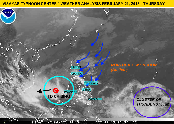
Cebu, PHILIPPINES- Tropical Depression "Crising" is finally out to the Philippine Area of Responsibility. At 4:00pm PAGASA, last located the center of the storm at 200 km west of Balabac, Palawan (8.0°N, 115.1°), packing a winds up to 45 kph and is moving west-northwest at 22 kph. Meanwhile, U.S Navy (JTWC) issued the final and last warning of the system and the Japan Meteorological Agency still issuing a warning.
Meanwhile Visayas (specially over Samar Is.) and Mindanao can still expect scattered light rains. Going further to the north (particularly over Eastern Luzon) expect light rains because of the Northeast Monsoon, the rest of Luzon including Metro Manila will experience fair weather except for those passing light rains.
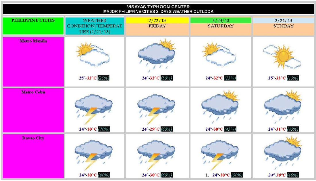
Here are the PHILIPPINE CITIES WEATHER OUTLOOK (3-DAYS) {NOT OFFICIAL}
 Satellite Image of TD Crising Cebu, PHILIPPINES- Tropical Depression Crising {02W} is now emerging Sulu Sea, at 4:00 am (PHT Time) the depression was last located 140 km northwest of Zamboanga City (7.5°N, 120.8°E). It's maximum sustained is still 45 kph . The depression is expected to move West Northwest at 24 kph, towards Southern Palawan.
(PSWS # 1: Southern Palawan, Zamboanga del Norte, Zamboanga del Sur, Zamboanga Sibugay, Basilan and Sulu)
• The rainbands of TD Crising is beginning to move north along Palawan,Visayas (particularly over Negros Oriental, Cebu, Bohol, Leyte, Samar and Siquijor) which means this areas will experience moderate to heavy rains to at times intense with gusty winds. By this afternoon MIMAROPA, CALABARZON and even in NCR we expect some light rains.
FORECAST OUTLOOK:
According to PAGASA 'Crising' is expected to be at 300km southwest of Puerto Princesa City tomorrow morning and by tomorrow afternoon it is expected to be at 570km southwest of Puerto Princesa.
GALE WARNING over EASTERN & CENTRAL VISAYAS and EASTERN MINDANAO
Due to Tropical Depression Crising PAGASA raised Gale Warning over the seaboards of Eastern and Central Visayas and the seaboards of Eastern Mindanao which means expect rough to very rough sea condition, fishing boats and other small sea crafts are advised not to venture over the said areas because/due to high waves.
Meanwhile a Low Pressure Area(LPA) has been located approximately 220 km Northwest of Puerto Princesa,Palawan (11.0°N, 117.0°E)
LATEST UPDATE OF LPA {98W}
LOCATION: outside of PAR / 351 km southeast of Palau Island / 1, 210 km east of Southern Mindanao
COORDINATES (per-weather-agency)
PAGASA : 6.0°N, 138.0°E
Japan Meteorological Agency : 6.0°N , 137.0°E
U.S Navy (JTWC) : 5.4°N, 137.1°E
MAXIMUM SUSTAINED WINDS{JTWC}: 18 kph to 27 kph (10 to 15 knots)
MINIMUM SEA LEVEL PRESSURE: 1004 MB
SEA SURFACE TEMPERATURE (over the LLCC): 28° to 30°C
MOVEMENT: WEST SLOWLY
CHANCE OF BECOMING A TROPICAL CYCLONE: LOW (>30%)
With this weather disturbance we've raised rainstorm warning which means expect moderate to heavy rains (5.0 to 15.0 mm/hr) which may trigger flash floods or landslide :
Rainstorm warning #2 (within 6 to 12 hrs.)
The whole Mindanao, Southern Negros, Southern Cebu, Siquijor, Bohol and Southern Leyte
Rainstorm warning #1 (within 12 to 24 hrs.)
Rest of Visayas and Palawan
[Note: Do not used this advisory/warning as life decision]
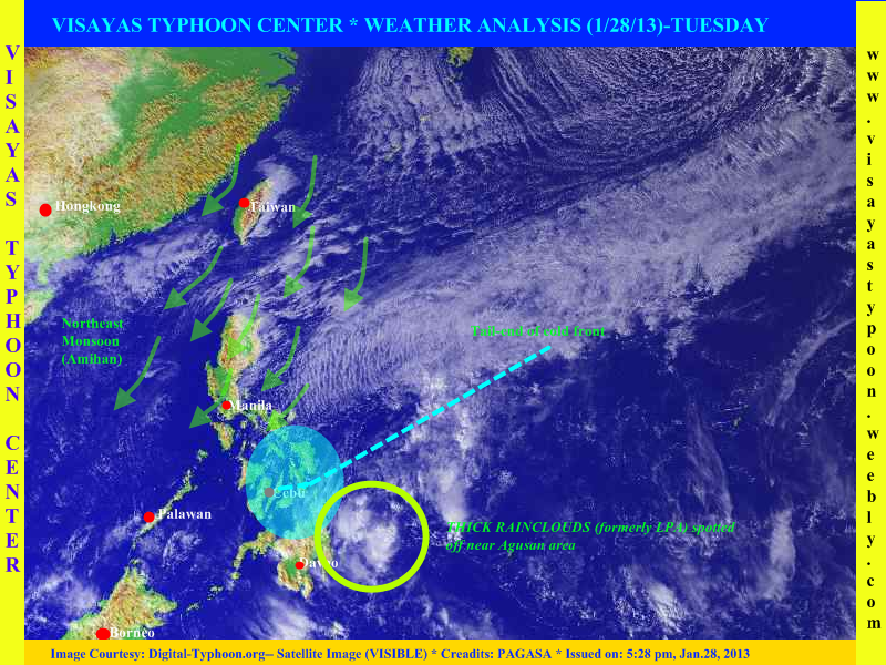
Latest Weather Analysis of Visayas Typhoon Center
Cebu, PHILIPPINES - The weak low pressure area which has been monitored last saturday has finally dissipate, it was last located east of CARAGA Region, this remnants of LPA is expected to bring scattered rains across CARAGA Region, Davao Region and even in Bukidnon. Going also in Visayas expect scattered rains across Eastern and Central Visayas, this rains is caused by a tail-end of cold front (buntot ng cold front-in tagalog). Meanwhile Western Visayas will experience partly cloudy with brief isolated rains. In Luzon especially on Eastern sections expect light rains with decreasing temperature.
Here are the 5 areas/places experienced low temperature yesterday -- PHILIPPINES
Baguio City (12°C)
Basco, Batanes (16°C)
Malaybalay, Bukidnon (18°C)
Itbayat (19°C)
Tanay, Rizal (19°C)
WEATHER OUTLOOK FOR TOMORROW
(This forecast is not 100% accurate)
LUZON.
Bicol Region, Cagayan Valley, Aurora and Quezon Provinces -> partly cloudy skies with light passing rains. Chances of rainshowers will be 20-40%
Rest of Luzon including Metro Manila -> fair with a small chance of precipitation (10 - 20%)
VISAYAS.
Eastern and Central Visayas -> cloudy skies with light to moderate to at times heavy rains. Chances of rainshowers will be 60-90%
Rest of Visayas -> cloudy skies with isolated light rains. Chances of rainshowers will be 45-80%
MINDANAO.
Eastern and Central Mindanao including Misamis Oriental and Bukidnon -> cloudy skies with light to moderate to at times heavy rains. Chance of rainshower will be 60-100%
Rest of Mindanao -> cloudy skies with light rains. Chances of rainshowers will be 45-80%
NEXT UPDATE WILL BE WEDNESDAY, JANUARY 30 2013
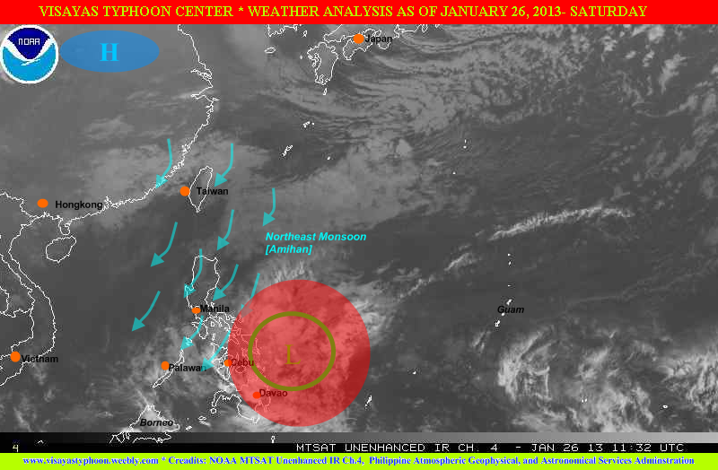
Latest Weather Analysis as of 1-26-13
Cebu,PHILIPPINES - A weak tropical disturbance (known as LPA) has been located at 547 km ENE of Metro Cebu / 410 km E of Guiunan, Eastern Samar. The tropical disturbance has a zero possibility of becoming a tropical depression. Although it's weak, but it's rainbands continues to affect Eastern and Central Visayas, Bicol Region and CARAGA, expect light to moderate to at times heavy rains acoss the areas mentioned. According to the NOAA (a weather site of USA) the system packed a winds of 15 knots equivalent to 27 kph.
Going to the north especially for Luzon expect decreasing temperature's especially in midnight. According to a report the Mt.Pulag experienced a temperature of 0°C, based on the park rangers in the area, but PAGASA did not confirmed the said report.
Tomorrow's WEATHER FORECAST FOR LUZON, VISAYAS and MINDANAO
(This outlook is not 100% accurate)
In Metro Manila, CALABARZON, MIMAROPA (except for Palawan) and Central Luzon the chances of precipitation is low (20%) , but in the Northern Luzon, eastern section of Central Luzon and Palawan expect medium to high chance precipitation (40-60%).
For Metro Cebu, Tagbilaran City, Ormoc-Tacloban Cities and Samar expect high chances of precipitation (60%). On the other hand the rest of Visayas (Iloilo-Bacolod-NegrosOriental and Siquijor) will expect medium to high chance of precipitation 40%-60%)
Meanwhile Metro Davao, ComVal,Surigao City and Agusan Provinces expect high chances of precipitation (60%), but going in Cagayan de Oro City, Bukidnon, Lanao Provinces expect medium to high chance of precipitation (40-60%). Rest of Mindanao expect medium chance of precipitation (40%)
THANK YOU
and ENJOY THE WEEKEND
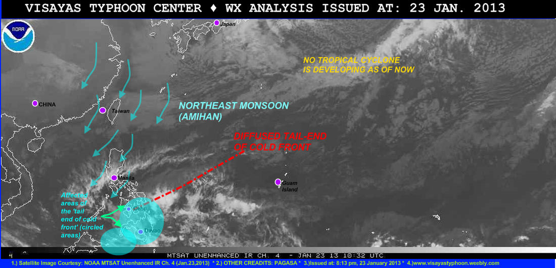
Here is the latest weather analysis of Visayas Typhoon Center as of January 23, 2013
Cebu, PHILIPPINES- Rainshowers continues to dominated across some parts of Visayas and Mindanao especially Eastern Visayas (Samar and Leyte Province), Central Visayas (Negros Province, Cebu, Siquijor and Bohol) and Eastern Mindanao (Surigao, Agusan, Davao and Compostela Valley) because of diffused tail-end of cold front {diffused means- papalayo}. Latest report coming fro GMA News TV, some roads in Compostela Valley is zero visibility and flashfloods were also been reported across North Cotabato and Datu Montawal in Maguindanao.
On the other hand the Low Pressure Area which has been monitored by PAGASA southeast of Gen.San City has been dissipate.
Going also to Luzon expect cold weather with light rains particularly in afternoon or evening.
Next Update will be on January 25, 2013
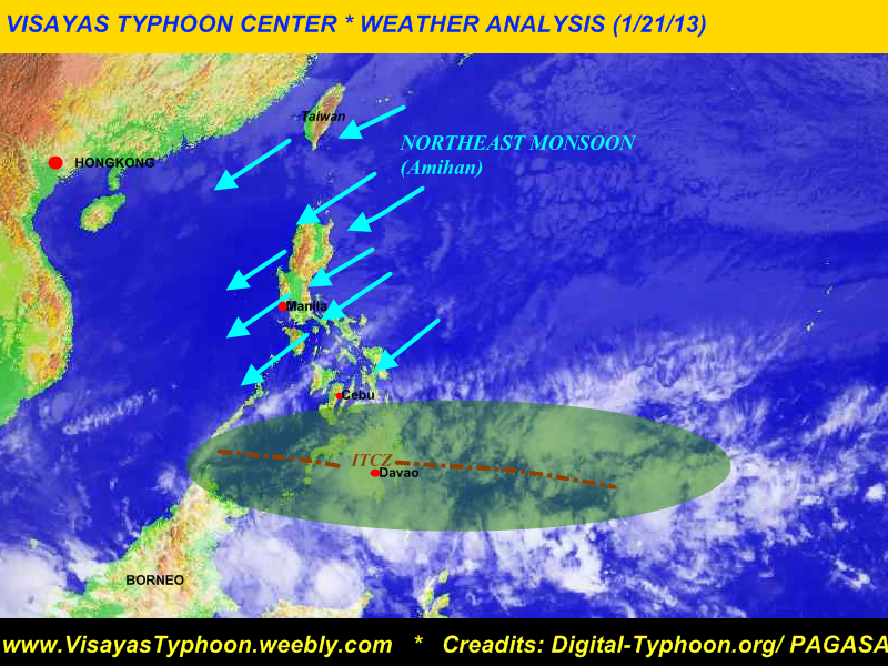
VISAYAS TYPHOON CENTER WEATHER ANALYSIS (1/21/13)IN THE PHILIPPINES
Cebu, PHILIPPINES - The weather system that bring heavy rains across Mindanao today, is not associated by a tropical cyclone/typhoon [as other people thought there is a cyclone name Cocoy]. Because as you could observe in the satellite image only the ITCZ (Intertropical Convergence Zone) is affecting Mindanao. According to the PHILIPPINE INFORMATION AGENCY-- REGION 11, there was one (1) casualty reported while 777 people were evacuated from 11 affected barangays in the province.
This rains is expected to affect Eastern and Central Visayas tonight or tomorrow. Latest tweet from PAGASA say's that there will be light to moderate rains expected over Leyte, Bohol and Cebu.
Going also to the north especially over Cagayan Valley, Aurora, Quezon Province and Bicol Region expect light passing rains and windy weather. Meanwhile the rest of Luzon will experience fair weather with brief isolated rain's. [[PAGASA recorded the lowest temperature for the month of January 2013 in Metro Manila (18.8°C)]]
Latest Gale Warning issued by PAGASA said that strong to gale force warning is expected to affect the whole seaboards of Luzon, eastern seaboards of Visayas and Mindanao so fishing boats and other small sea crafts is not allowed to venture to the sea.
AGAIN there is no tropical cyclone affects Mindanao today.
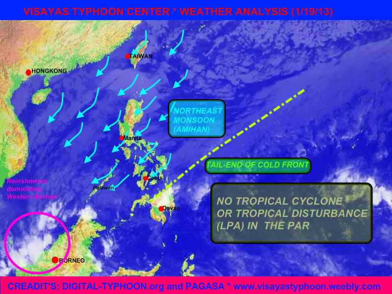 Weather Analysis in the Philippines as of Jan.19,2013 Cebu, PHILIPINES- The Northeast Monsoon (locally known as Amihan) is affecting Luzon and Visayas, which cause windy weather across the region and light passing rains. According to PAGASA expect decreasing temperature due to the Northeast Monsoon in Luzon and Visayas. Here are the five places (5) which experience low temperatures yesterday: - Baguio (9°C)
- Basco (12°C)
- Itbayat (15°C)
- Tuguegarao (16°C)
- Malaybalay (17°C)
*Source: Wunderground.comMeanwhile the PAGASA raised Gale Warning in the seaboards of Luzon, Visayas and Eastern Mindanao which means fishing boats & other small sea crafts are not allowed to venture to the seas.On the other hand going also in the Mindanao esp. the Northern and Eastern Mindanao which the tail-end of cold front continues to affect expect light to moderate rains in the said areas.Thank you and PIT Senyor!!
Here are the some possible track of the LPA southeast of Mindanao . First possible track will be towards Eastern Visayas then towards Bicol Region area. Second possible track will cross Cebu then move to the North towards Bicol Region, and the last possible track it will cross Northeastern Mindanao then towards the Visayan Island (Image Courtesy: SpagModel)
Cebu, PHILIPPINES -
LATEST UPDATE FOR TROPICAL DISTURBANCE 94W:
Location:
PAGASA (PHILIPPINES): 480 km southeast of Gen.Santos City
JTWC(US Navy): 748 km east-southeast of Zamboanga City
JMA (Japan Met.Agency): sea of east Mindanao
Coordinates:
PAGASA (as of 8am, PHT Time) 3.4°N, 128°E
JMA (as of 0600 UTC) 4.6°N, 129.0°E
JTWC (as of 2pm, PHT Time) 3.9°N, 129.3°E
Maximum Sustained Winds: 55 kph (JMA- Japan Met.Agency)
(The Japan Met. Agency [JMA] has upgraded the system into a tropical depression)
Movement: JMA (Japan MET. Agency): Northward slowly
Central Pressure: JMA (Japan Met.Agency) 1002 hPa
In order to be prepare especially in the areas of Visayas and Mindanao we have raised rainstorm warnings in the following areas which means expect moderate to heavy rains (5.0 to 15.0mm/hr:) which may trigger flashfloods and landslides
[Note: Do not use this warning/advisory in life decision)
Rainstorm Warning # 3 (starting now or within 6hrs.)
The Whole Mindanao
Cebu
Bohol
Leyte Provinces
Samar Provinces
Rainstorm Warning #2 (within 6 to 12hrs.)
Rest of Visayas and the Eastern portions of Palawan
Rainstorm Warning #1 (within 12 to 24hrs.)
Bicol Region, Masbate, CALABARZON, Mimaropa, NCR and the rest of Palawan
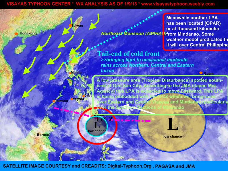
Cebu, PHILIPPINES- The low pressure area (tropical disturbance) which has been out the PAR yesterday, has entered again the PAR and spotted at 150km SE of General Santos City. According to the 24 hr. forecast track of Japan Meteorological Agency, this system will move eastward. The LPA also is embedded along the Inter tropical Convergence Zone [ITCZ] which bring rains across Visayas and Mindanao specially on the southern portions. Going also to the north (LUZON) there is also tail-end of cold front and the NE monsoon affecting to it so expect light to occasional moderate rains.
On the other hand there was also a tropical disturbance outside of PAR (about 1,190 km east of Mindanao), this LPA is expected to enter the PAR tomorrow afternoon or evening, there is also a chance that this LPA will be dissipate.
|
 RSS Feed