Latest Weather Analysis as of 1-26-13
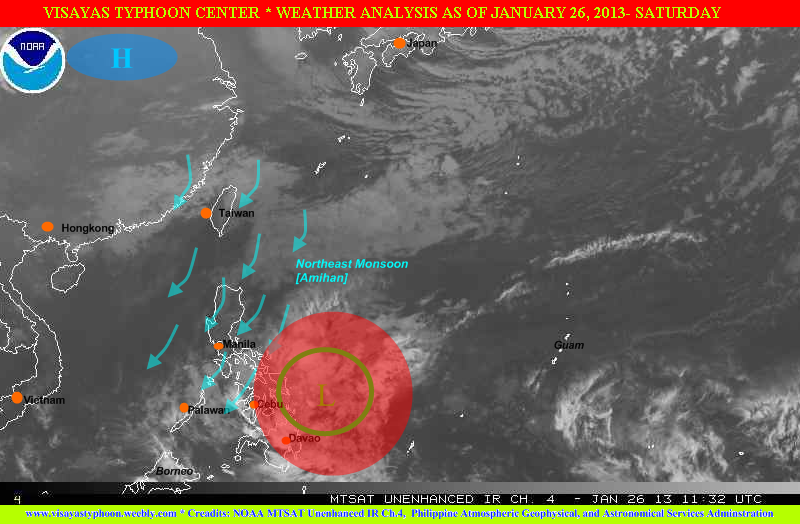
Cebu,PHILIPPINES - A weak tropical disturbance (known as LPA) has been located at 547 km ENE of Metro Cebu / 410 km E of Guiunan, Eastern Samar. The tropical disturbance has a zero possibility of becoming a tropical depression. Although it's weak, but it's rainbands continues to affect Eastern and Central Visayas, Bicol Region and CARAGA, expect light to moderate to at times heavy rains acoss the areas mentioned. According to the NOAA (a weather site of USA) the system packed a winds of 15 knots equivalent to 27 kph.
Going to the north especially for Luzon expect decreasing temperature's especially in midnight. According to a report the Mt.Pulag experienced a temperature of 0°C, based on the park rangers in the area, but PAGASA did not confirmed the said report.
Tomorrow's WEATHER FORECAST FOR LUZON, VISAYAS and MINDANAO
(This outlook is not 100% accurate)
In Metro Manila, CALABARZON, MIMAROPA (except for Palawan) and Central Luzon the chances of precipitation is low (20%) , but in the Northern Luzon, eastern section of Central Luzon and Palawan expect medium to high chance precipitation (40-60%).
For Metro Cebu, Tagbilaran City, Ormoc-Tacloban Cities and Samar expect high chances of precipitation (60%). On the other hand the rest of Visayas (Iloilo-Bacolod-NegrosOriental and Siquijor) will expect medium to high chance of precipitation 40%-60%)
Meanwhile Metro Davao, ComVal,Surigao City and Agusan Provinces expect high chances of precipitation (60%), but going in Cagayan de Oro City, Bukidnon, Lanao Provinces expect medium to high chance of precipitation (40-60%). Rest of Mindanao expect medium chance of precipitation (40%)
THANK YOU
and ENJOY THE WEEKEND
 RSS Feed