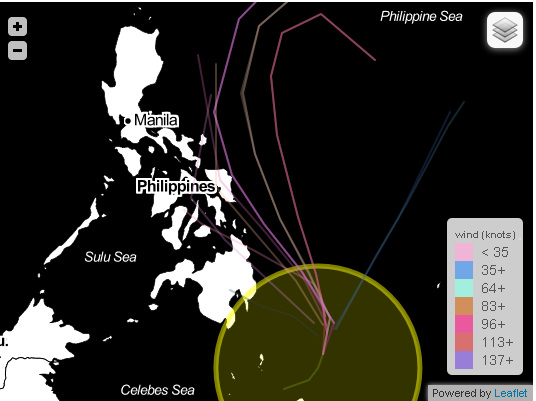
Here are the some possible track of the LPA southeast of Mindanao . First possible track will be towards Eastern Visayas then towards Bicol Region area. Second possible track will cross Cebu then move to the North towards Bicol Region, and the last possible track it will cross Northeastern Mindanao then towards the Visayan Island (Image Courtesy: SpagModel)
Cebu, PHILIPPINES -
LATEST UPDATE FOR TROPICAL DISTURBANCE 94W:
Location:
PAGASA (PHILIPPINES): 480 km southeast of Gen.Santos City
JTWC(US Navy): 748 km east-southeast of Zamboanga City
JMA (Japan Met.Agency): sea of east Mindanao
Coordinates:
PAGASA (as of 8am, PHT Time) 3.4°N, 128°E
JMA (as of 0600 UTC) 4.6°N, 129.0°E
JTWC (as of 2pm, PHT Time) 3.9°N, 129.3°E
Maximum Sustained Winds: 55 kph (JMA- Japan Met.Agency)
(The Japan Met. Agency [JMA] has upgraded the system into a tropical depression)
Movement: JMA (Japan MET. Agency): Northward slowly
Central Pressure: JMA (Japan Met.Agency) 1002 hPa
In order to be prepare especially in the areas of Visayas and Mindanao we have raised rainstorm warnings in the following areas which means expect moderate to heavy rains (5.0 to 15.0mm/hr:) which may trigger flashfloods and landslides
[Note: Do not use this warning/advisory in life decision)
Rainstorm Warning # 3 (starting now or within 6hrs.)
The Whole Mindanao
Cebu
Bohol
Leyte Provinces
Samar Provinces
Rainstorm Warning #2 (within 6 to 12hrs.)
Rest of Visayas and the Eastern portions of Palawan
Rainstorm Warning #1 (within 12 to 24hrs.)
Bicol Region, Masbate, CALABARZON, Mimaropa, NCR and the rest of Palawan
 RSS Feed