Due to the Low Pressure Area (LPA), east of Southern Mindanao. Visayas Typhoon Center raised RAINSTORM WARNING'S several areas in Visayas and Mindanao:
Rainstorm Warning #3 (starting now or within 6hrs.)
Compostela Valley, Davao Oriental, Davao del Norte, Davao del Sur, Davao Oriental including Samal Island, South Cotabato, Sultan Kudarat, Sarangani and North Cotabato
Rainstorm Warning #2 (expect heavy rains within 6 to 12hrs.)
Southern Cebu, Southern Negros, Siquijor, Bohol and Southern Leyte
Rest of Mindanao including Sulu, Basilan and Tawi-Tawi
Rainstorm Warning #1 (expect heavy rains within 12 to 24hrs.)
Northern Cebu, Northern Negros, Northern Leyte, Western Samar, Iloilo and Guimaras
[NOTE: DO NOT USED THIS WARNING/ADVISORY, IN LIFE DECISION, KINDLY REFER TO PAGASA, WHICH IS THE OFFICIAL WEATHER BUREAU]
Due to the Low Pressure Area (LPA), east of Southern Mindanao. Visayas Typhoon Center raised RAINSTORM WARNING'S several areas in Mindanao:
Rainstorm Warning #2 (expect heavy rains within 6 to 12hrs.)
Compostela Valley, Davao Oriental, Davao del Norte, Davao del Sur, Davao Oriental including Samal Island and Agusan del Sur
Rainstorm Warning #1 (expect heavy rains within 12 to 24hrs.)
Surigao del Norte, Surigao del Sur, Agusan del Norte, Siargao and Dinagat Island, Bukidnon, North Cotabato, South Cotabato, Sultan Kudaratat, Sarangani, Maguindanao, Lanao del Norte, Lanao del Sur, Misamis Oriental and Camuigin
[NOTE: DO NOT USED THIS WARNING/ADVISORY, IN LIFE DECISION, KINDLY REFER TO PAGASA, WHICH IS THE OFFICIAL WEATHER BUREAU]
CEBU, Philippines - The tropical disturbance that has been monitored yesterday by PAGASA, has enter the Philippine Area of Responsibility, Saturday afternoon. According to the NOAA (a weather portal in USA), the system packed a winds up to 28kph. It's central pressure is estimated to be at 1010 mb, they also located the LPA at 4°N, 136.5°N; meanwhile the PAGASA located it at 6°N, 136°E. The said disturbance is embedded along the Intertropical Convergence Zone that bring rains across the Mindanao and Central visayas. Going also to the north, light to occasional rains shall be expected due to the Northeast Monsoon (Amihan)
VISAYAS TYPHOON CENTER '94W' Probability of becoming a tropical depression: 35% (LOW)
RAINSTORM WARNING #1 (heavy rains will be expected within 12 to 24hrs.)
MINDANAO: Compostela Valley, Davao Oriental and Samal Island
[Note: Do not use this warning in life decision, Kindly refer to PAGASA for the official weather warning]
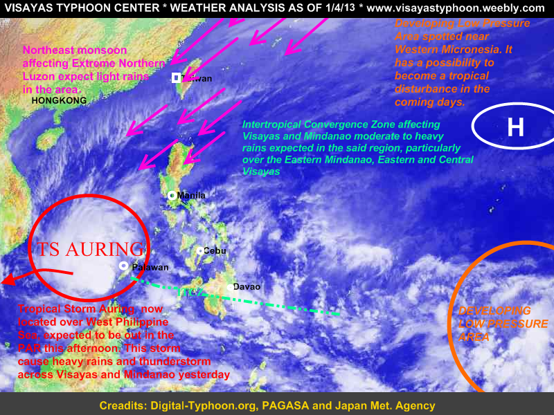
Cebu, PHILIPPINES- Tropical Storm Auring has made landfall over Southern Palawan, now located over West PHL Sea. It is expected to be out in the PAR this afternoon.
(Public Storm Warning Signal #2 over Southern Palawan, while the rest of Palawan is under signal #1)
Meanwhile Visayas and Mindanao shall still expect moderate to heavy rains especially in the Eastern sections of Mindanao and the Eastern and Central Sections of Visayas. Going also here in the Northern Luzon expect light rains because of the Northeast Monsoon, while the rest of Luzon expect fair and good weather
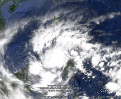
As we could see in the satellite image a developing low pressure area near Western Micronesia this system is expected to become a tropical disturbance in the coming days.
 CEBU, PHILIPPINES-
LATEST UPDATE OF TROPICAL DISTURBANCE 92W
Location: 62 km east-northeast of Ozamis City
Coordinates: 8.30°N, 124.4°E
Maximum Sustained Winds: 55 kph
Central Pressure: 1004 hPa
RAINBANDS affecting Western and Central Visayas including Leyte Provinces, Northern and Western Mindanao (expect moderate to heavy rains along the rainbands of 92W):
 A tropical disturbance (known as LPA) has been spotted southeast of Mindanao. According to the latest weather bulletin of PAGASA, the LPA has been located at 1,020km Southeast of Mindanao with a coordinates of 5.0°N, 136.0°E. They also forecast that the system is embedded along with the ITCZ which bring light to moderate rains across the Leyte Provinces and Mindanao.
Latest Japan Weather Bureau (Japan Meteorological Agency) has upgraded the system into a tropical depression., Meanwhile the US Navy (JTWC) didn't issue any warning in this system.
Here are the possibilities which can possibly develop the disturbance into a tropical depression:
> relatively warm sea surface temperature (over the WesPac)
> decreasing wind shear
> good low level convergence coupled with high level divergence exists over the area.
 CEBU, PHILIPPINES - After Tropical Storm 'Quinta' afects the Visayas on Christmas Day. Another weather system is expected to affect the Visayan Region and Mindanao Region (specially on Eastern and Central Sections of Visayas) called the tail-end of cold front, which will affect in the said region starting Dec.31, 2012 til' Jan.2, 2013 (expect cloudy skies with scattered rainshowers). Thus areas which has been greatly affected by TYPHOON PABLO, should expect scattered to widespread rainshowers and thunderstorm (Davao Oriental and Compostela Valley) , while the rest of Mindanao will expect cloudy skies with light to scattered rainshowers. Going also here in the Visayas, the Eastern and Central Section will experience cloudy skies with scattered to widespread rainshowers (Cebu, Negros Or., Bohol, Leyte and Samar). Thus areas which has been greatly affected by TROPICAL STORM QUINTA, will still expect rains but not to heavy.,
Meanwhile another weather system which will affect Northern Luzon and Eastern Luzon (CAGAYAN VALLEY, CAR, ILOCOS REGION, AURORA,QUEZON, BICOL REGION) will be the Northeast Monsoon (AMIHAN) were'in expect light rains/light passing rains., Fishing boats and other small sea crafts are not allowed to venture in the sea because of the strong winds generated by AMIHAN.
THANK YOU!!
AND HAVE A GOOD DAY!
 TROPICAL DEPRESSION QUINTA forecast track Cebu, PHILIPPINES- Tropical Disturbance '93W' has finally reached into a tropical depression and it's codename in the Philippines 'Quinta'. Tropical Depression Quinta continues to intensity and has a possibility to become a tropical storm. Both weather agencies namely JTWC and PAGASA has upgraded the tropical disturbance into a tropical depression, while JMA has been upgraded it already to a tropical depression yesterday. The system was last located at about 330km east of Surigao City (10.3°N, 129.5°E). Maximum sustained winds at 55 kph and is moving West at 19kph. It is expected to made its first landfall in Dinagat Island, and will pass the Central Visayas then Western coast of Visayas.
Latest satellite image shows the significant improvements 27W has made in terms of organization overnight. The convective activity has increased and has also become more consolidated near the low-level center.
PSWS #1 has been raised in 9 areas namely Leyte, Southern Leyte, Eastern and Western Samar, Surigao Del Norte, Dinagat Island, Surigao del Sur, Agusan Provinces, Camiguin Island. (This area's will expect rains and gusty winds).
According to the PAGASA the estimated rainfall of Tropical Depression 'Quinta' is from 5-15 mm/hr (moderate to heavy), and a diameter of 300km.
WE ARE EXPECTING THAT MORE PROVINCES WILL BE RAISED IN THE STORM WARNING'S
Thank you!
and
Merry Christmas!
 Cebu, PHILIPPINES- The low pressure area or tropical disturbance '93W'
which has been monitored by the JMA (Japan Meteorological Agency) has entered the Philippine Area of Responsibility this morning. According to the PAGASA this system will make landfall over Surigao-Leyte Area and could bring rains across the Bicol Region, the Whole Visayas and Mindanao.
If the LPA intensified into a tropical depression it's named will be "Quinta"
Meanwhile Japan Meteorological Agency upgraded this system into a tropical depression and is moving WNW at 28KPH. It is packing a winds up to 55 Kph towards the Seaboard of Eastern Mindanao.
In order to be prepare we've raised rainstorm warning signals in the following area:
Rainstorm Warning #3 (heavy rains within 6 to 12 hrs.)
Northern part of Iloilo, Northern part of Negros Provinces, Siquijor, The Whole Cebu Provinces, Bohol, Leyte, Southern Leyte, Eastern and Western Samar,Surigao Del Norte, Surigao Del Sur, Siargao and Dinagat Grp. of Island, Agusan Del Norte, Agusan Del Sur, Davao Provinces, Compostela Valley, Bukidnon, Camuigin
Rainstorm Warning #2 (heavy rains within 12 to 24 hrs.)
Masbate, Romblon ,Aklan, Capiz, Rest of Iloilo, Rest of Negros Provinces, Northern Samar, Antique, Misamis Oriental, Misamis Occidental, Zamboanga Del Norte, North Cotabato, Maguindanao, Lanao del Norte, Lanao del Sur
Rainstorm Warning #1 (heavy rains within 24 to 36 hrs.)
Bicol Region, Batangas, Cavite, Laguna, Rizal, Quezon, Mindoro Provinces, Palawan, Metro Manila, Rest of Mindanao
Note: Kindly refer to your weather bureau
|


 RSS Feed